Weekly Gem #50 Have a gneiss day
Published 12/5/2015
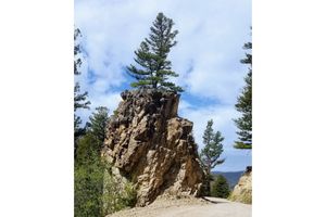
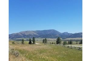
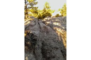
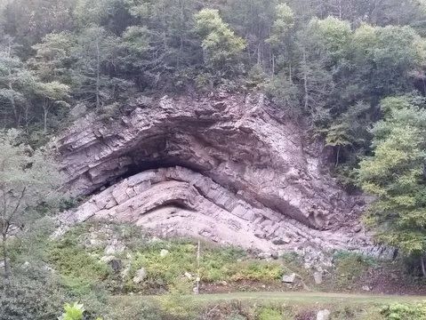
Location: This 'hidden gem' is about half a mile southeast of Huntersville, WV, on the south side of highway 39 (see Clue Me! map). As they drive by, some people take it for granite ... but anyone worth their basalt will know this is gneiss, and will appreciate the amazing sequence of events that created this formation, and made it visible.
Consider the history of our interestingly shaped rock:
First, remember (or note) that supercontinents come and go, as major continental plates jostle for position ... the plates drift, rotate, sink, and rise, sometimes together and sometimes apart.
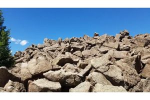
This rock, called the Devil's Backbone, began as a sand deposit. The sand piled up around 450 million years ago, likely part of an ocean that formed after the Pannotia supercontinent split up, and before Pangaea formed. Maybe it was a pleasing beach, where some sea scorpions would hang out. The sand was gradually buried and compressed until it first became sandstone (rock with individual sand grains) and eventually was far enough underground that the heat changed sandstone to quartzite (has an interlocked crystal structure, that is much harder than sandstone).
Time passes. Continents drift. Chunks of the earth's crust swoop in from the southeast, pushing with incredible force into this area. Oh look! Here comes Africa!
Africa arrived (in conjunction with the formation of Pangaea) about 200 million years after the sand deposit first formed, and while these rocks were still a few miles underground.
Under constant pressure pressure for tens of millions of years, the hard quartzite was bent and compressed into parallel 'waves,' something like an old washboard. These waves were in turn pressed and bent. As Africa drifted back east about 50 million years ago, the entire area lifted, forming the Appalachian mountain range. These mountains are old, highly eroded, with the quartzite and gneiss left behind after softer rocks eroded away. On a satellite view of the eastern U.S., you can see the ridges formed by the metamorphic rock, separated by valleys (visible if you zoom in) where softer rock used to lie. These ridges and valleys run from central Pennsylvania to Birmingham, Alabama. Notice the massive curves where entire sections of crust bent while the rock was deep enough underground to behave like taffy. Then it all lifted at the same time (geologically speaking), and those curves remained.
Now, the last piece of the puzzle. Knapp Creek mostly runs 'with the grain' of the Appalachians, just like every other creek. But at this spot it runs 'across the grain,' cutting across the hardest metamorphic rocks. Some 50 million years ago, Knapp Creek found the rare crack that cut across the gneiss, and has been carving away ever since. This is one of the few naturally occurring east to west slices across an Appalachian mountain ridge, and it's this slice across the ridge that allows us to see the Devil's Backbone.
For those who weren't attuned to these amazing facts at first, we'll just chalk it up to experience, and let them start with a clean slate.
.........
Here's the hidden gem entry from our Clue Me! map.
Clue
All bent out of shape.
Description
Devil's Backbone (Huntersville Anticline)
Why It's Interesting
This is a great example of how rocks can bend. This rock was folded as the mountains formed. Have a gneiss day!